Singapore Kampong Bengkulu
- Marc Michelmann
- Sep 28, 2025
- 11 min read
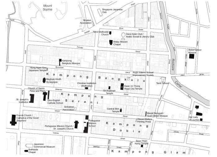
Although the area was designated as the ‘European Town’, this label was never used by the locals, who instead named the area according to how they perceived it. In Hokkien, Albert Street was known as Kam Kong Mang Ku Lu (Kampong Bengkulu), ‘Mang Ku Lu’ being the transliteration of ‘Bengkulu’.
Kampong Bengkulu (Bencoolen) encompassed the properties at present-day Albert Street, Prinsep Street, Bencoolen Street, Short Street, Middle Road and Waterloo Street.
Newspaper notices from early as 1844 indicate that addresses at Queen Street and Church Street (later renamed Waterloo Street) were usually accompanied by the words ‘Campong Bencoolen’. For instance, a forum letter contributor to the local newspaper in 1846 wrote “Queen Street, Campong Bencoolen” and signed off as “A Resident in Church Street, Campong Bencoolen”.
Diverse Places of Worship
At the centre of Kampong Bengkulu was a mosque of the same name, built in 1845. Like the mosque in Kampong Melaka, Masjid Kampong Bengkulu was a recipient of Syed Omar bin Ali Aljunied’s wakaf (a permanent endowment for charity). Pre-dating the mosque, however, were two churches: the Catholic Chapel (1833) and the Malay Chapel (1843; also known as Greja Keasberry), which in 1885 became the Prinsep Street Presbyterian Church. The existence of these early churches in Kampong Bengkulu can be traced to its earlier demarcation as the European quarter before the kampong took shape. Records indicate that by the mid-19th century, Malays and other groups were present in the area alongside Europeans and Eurasians as both residents and building owners.

In 19th-century Singapore, the colourful, multiethnic composition of the area was apparent with the diversity of its religious landmarks. The latter half of the century saw the establishment of St Joseph’s Church (1853) on Victoria Street by the Portuguese Mission; Bethesda Chapel (1866) on Bras Basah Road; Sri Krishnan Temple (1870), Maghain Aboth Synagogue (1878) and Kwan Im Thong Temple (1884) on Waterloo Street; Our Lady of Lourdes Church (1886) on Queen Street catering to Tamils from Pondicherry, India; and the Tamil Methodist Church on Short Street (1887).

Sri Krishnan Temple, No. 152 Waterloo Street, August 2024

Sri Krishnan Temple, No. 152 Waterloo Street, August 2024
Forgotten Lorongs
A unique feature of Kampong Bengkulu was its relatively large building plots. These were originally intended for the substantial mansions or compound houses used by the European community. While some of these plots were used for large houses, others were subdivided for the building of shophouses. Because the shophouses occupied only a third of the large plot sizes, property developers created alleys or lanes (lorong in Malay) to access the interior of the plots and built microtenements there. The only surviving example of such a land division in the area is Prinsep Place, formerly known as Cheang Jim Chuan (Chwan) Place.
The developers of four lorongs in Kampong Bengkulu have been identified as Hadjee Mohamed Bin Abdul Rahim (Lorong Sakai), Hussensah Marican (Lorong Serai), Haji Kader (Lorong Sepang) and S. Kassim (Lorong Kassim). It is significant that these four personalities were either Malay or Indian; Haji Kader and S. Kassim were Tamil Muslim merchants from Bombay who were part of the Jawi Peranakan community.
Indeed, there was an exceptionally large number of Arabs and Tamil Muslims who owned properties or lived in Kampong Bengkulu. A search of land records from the 1840s shows that more than half of the total number of plots at lower Prinsep Street, lower Bencoolen Street and lower Waterloo Street, as well as the northwestern corner of Bras Basah and North Bridge roads, were owned by Arabs or Indian Muslims.
Source: https://www.roots.gov.sg/stories-landing/stories/forgotten-histories, September 2025
Bencoolen Street
This street was named both in remembrance of Sir Stamford Raffles' (1781-1826) sojourn at Bencoolen (Sumatra) as Lieutenant Governor, as well as in keeping with the fact that it was located in Kampong Bencoolen. When Raffles came from Bencoolen to Singapore, a number of Bencoolen Malays came as well, and settled in the vicinity of Bencoolen Street.
When the British gave up its possessions in Sumatra (Fort Marlborough in Bencoolen) after the signing of the Anglo-Dutch Treaty of 1824, these numbers grew. Most of the oldest Singapore Malays and some Eurasian families are descended from these Bencoolen settlers.
Besides the road name, the only other reminder of these Bencoolen Muslims is the Bengali Mosque in Bencoolen Street. This mosque was probably built as an attap building in 1825-1828 by the Bencoolen Muslims living in this area. Around 1845. an Arab merchant from Palembang, Syed Omar bin Aljunied (1792-1852) built the presently existing building. The graveyard for these Bencoolen Muslims was located in what is now part of the Istana grounds (facing Orchard Road). The Chinese in pre- war days sometimes referred to this street as chai tng au boi, meaning "behind the vegetarian hall", alluding to the meeting house of the Chinese vegetarian guild located here.
Source: Singapore Street Names, 4th Edition, by Victor R. Savage and Brenda S. A. Yeoh, pg. 50

81 Bencoolen Street, September 2025

Source: https://thelongnwindingroad.wordpress.com/2012/10/16/lost-in-space/, September 2025

Source: https://eresources.nlb.gov.sg/newspapers/digitised/page/straitstimes19900515-1.1.2, September 2025
Albert Street
This street was named after Prince Albert, (1819-1861), consort to Queen Victoria, in March 1858 by the Municipal Commissioners. Albert Street in the early days was part of Kampong Bencoolen, an area occupied by Muslims from Bencoolen, Sumatra. In the Chinese vernacular, the street used to be known as kam kong mang ku lu (Kampong Bencoolen), or sometimes bo moa iu koi (the street where oil is extracted from sesamum). In the early 19th century, Hindus held their fire walking ceremony in Albert Street before it became a regular ritual at the Sri Mariamman Temple on South Bridge Road. Tamils thus used to call this street thimiri thidal (the place where people tread on fire). Up to the 1980s, the Rochor area was well-known for Chinese fire-walkers during the birthday of the monkey god.
From a culinary perspective, this street is best remembered for the Chinese restaurant, Wing Seong (184 Albert Street), better known as Fatty's Restaurant because of the Buddha-like figure of Au Chun Seng, the owner. The restaurant opened in 1918, beginning with Au Yuen, followed by his son Au Chun Seng and now the grandson, Au Kok Weng. In July 1986, Fatty's Restaurant moved from its shophouse location to the air-conditioned Albert Complex.
Source: Singapore Street Names, 4th Edition, by Victor R. Savage and Brenda S. A. Yeoh, pg. 17

Timithi Festival.
Source: https://www.roots.gov.sg/ich-landing/ich/theemithi, September 2025
The festival of Timithi (also spelt Theemithi, meaning fire walking in Tamil) marks a Hindu ceremony during which male devotees walk across a fire pit in prayer to the goddess Draupadi Amman. The festival was introduced in Singapore by the caulker community, who specialised in boat building and who traced their roots to the seaside Cuddalore and Poigainallur areas in South India. They brought with them the cult of Draupadi, a Tamil folk goddess associated with the Mahabarata, an Indian epic. Albert Street was once the location for Timithi which is one of the two oldest Hindu festivals in Singapore. The street was known as Thimiri Thidal (or “the place where people tread on fire” in Tamil) to Indians. In 1870, Timithi was relocated to the Sri Mariamman Temple at South Bridge Road, where it continues to be held to this day.
Source: https://www.roots.gov.sg/Collection-Landing/listing/1510495. September 2025
Prinsep Court/Street
Prinsep Street was formerly known as Flint Street and is found in the 1836 map of the town of Singapore drawn from a survey by G.D. Coleman. The street was renamed Prinsep Street by the municipal authorities in March 1858 after Charles Robert Prinsep (1789-1864) who was a household name in Singapore in the 1840s. Prinsep was a barrister with the East India Company based in Calcutta. He was also a plantation owner and the man behind the second phase of the hills' development. He may have first purchased Bukit Caw from the Farquhar estate in 1831, adding to it a huge tract of land that extended to Mount Sophia and Mount Caroline, soon after. Prinsep owned a large nutmeg plantation which Dr Oxley estimated in 1848 to have 6,700 trees. The Prinsep plantation carried a variety of plants: nutmegs, coffee, areca nut, orange trees and clove trees. The estate covered 250 acres that stretched from Stamford Road to Bukit Timah and as far inland as Cairnhill. Prinsep Street was the road that cut through Charles Prinsep's plantation.

Source: https://www.roots.gov.sg/Collection-Landing/listing/1074267, September 2025
Charles Scott (1802-1858) lived in an attap house where the current Istana is located and looked after Prinsep's nutmeg estate while he was away in Calcutta. Prinsep finally left Singapore for Calcutta in 1854 and his estate was sold in parts in 1860. The land of the current Istana (then Government House) was bought by the colonial government under Governor Ord's tenure, Prinsep Court was officially named in 1957, Prinsep Street was known as mang ku lu sau lo koi in Hokkien, meaning "scavenging street in the Bencoolen district", Scavengers' carts were kept at the corner of Prinsep Street.
Source: Singapore Street Names, 4th Edition, by Victor R. Savage and Brenda S. A. Yeoh, pg. 403
Short Street (Selegie-Middle Road area)
While some say it was named after Septimus Short, a banker, who spoke on public issues related to rail ways and docks, we posit that it was so named because it was a very short street (350 metres long). Formerly, there used to be cantonments nearby. Short Street, however, is not the shortest street currently in Singapore: Finlayson Green is the shortest road (80 metres long).
Septimus Short was the longest serving officer in the Mercantile Bank and always showed zeal and ability. The directors held him in the highest esteem but only later increased his salary. However, due to inappropriate handling of opium transactions, he was dismissed from the bank. The bank lost money as a result of his "blind confidence and wilful neglect".
This street was part of four adjacent streets (Short Street, Selegie Road, Middle Road, and Wilkie Road) in the vicinity that formed the mahallah or Jewish quarter in Singapore in the early 20th century. The mahallah in the 1920s and 1930s comprised poorer religious Baghdadi Jews. . The Jewish presence can be seen in several buildings in the area which have the Star of David on the buildings and are now preserved. Short Street and Wilkie Road with its predominantly old Jewish influence still has a colonial bungalow housing the Abdullah S. Shooker Home (81 Wilkie Road) for elderly and poor Jews. Buildings that line this street were of mixed ethnic and commercial use that included the David Elias Building, the Tamil Methodist Church and the Golden Wall Centre.
It was known as tek kha so si tek bang in Hokkien, which means "so si tek lane in tek kha". So si tek is "short" in Chinese, and tek kha means the Selegie Road-Little India district.
Source: Singapore Street Names, 4th Edition, by Victor R. Savage and Brenda S. A. Yeoh, pg. 461
Middle Road
One of the roads already in existence in early Singapore appears in Coleman's 1836 Map of Singapore. Despite its rather bland name, Middle Road has a colourful history. Like the Singapore River in the 1822 Jackson Plan which demarcated the European sector (north of the River) from the Asian sector (south of the River) of the early Singapore town, Middle Road formed another demarcation line between the boundaries of the White colonial civic town and the ethnic settlements (e.g. Kampong Glam). The Chinese name for the road is sio poh ang mo pah thi, which literally meant "small town European foundry", The Chinese name refers to the foundry that was located in Middle Road, originally owned by Messrs Cazalas and later by the Ban Hap Kongsi. In the 1950s and 1960s, Middle Road was well known for its numerous shoe shops.
Middle Road was the site of three distinctive ethnic agglomerations in Singapore's history. Firstly, it was initially occupied by the immigrant Hainanese Chinese community, well-known for their active role in the food and beverage industry. The Hainanese were concentrated around Middle Road stretching from North Bridge Road to Beach Road, They called the road Hainan Yi Jie or Hainan First Street to signify the importance of the street to the Hainanese community.

Behind no. 21 Middle Road, September 2025
Secondly, from the late 19th century till the 1940s, a little Japanese quarter was located in the area surrounding Middle Road, Hylam Street and Malay Street. A famous shop along Middle Road was Echigoya, a Japanese fabric store known for its fine textiles and garments, From 1889 to the beginning of the Second World War, there were many Japanese residents in Singapore, Just as the Chinese called their Chinatown 'toa poh' or big town, so the Japanese called Middle Road their "Shitamachi" or 'downtown', and the road was referred to as "Central Street" or Chuo Dori. This Japanese enclave was also the site of brothels and Japanese prostitutes or Karayuki-san as well as traditional shops operated by Japanese traders and shopkeepers. The Japanese community numbered around 6,950 at the turn of the 20th century. They also introduced the jinricksha in 1894, which became a major mode of transportation in downtown Singapore.
Thirdly, at the other end of Middle Road (near Selegie Road, Wilkie Road and Mount Sophia) was the Jewish sector in the early 20th century (1920s and 1930s). In the vicinity of the Maghain Aboth Synagogue along Waterloo Street was a mahallah (Jewish Quarter) for the poorer Baghdadi Jews. Many of today's well-known Jewish businessmen were brought up in this area, including the late Jacob Ballas. The most famous landmark of this past mahallah is the David Elias Building where Middle Road, Short Street and Wilkie Road converge. The David Elias Building built in 1928 was the property of the Jewish merchant, David D.J. Elias, The building carries the signature Star of David, which is a symbol of its Jewish ownership.
The road was also known as mang ku l chia kaun in Hokkien, meaning "Jinrikisha depot in Bencoolen".
Source: Singapore Street Names, 4th Edition, by Victor R. Savage and Brenda S. A. Yeoh, pg. 339
Waterloo Street (Rochor Road to Stamford Road)
This street was formerly known as Church Street after Thomas Church (1798-1860) who was a British colonial administrator under the British East India Company and became a Resident Councillor in 1837. Church started as a writer in Bencoolen (Bengkulu) in 1816 and rose to the high position of Resident Councillor of Singapore before retiring in 1856.

No. 42 Waterloo Street, June 2022
A survey of this street was done by J.T. Thomson (1821-1884) and it was probably he who used Church's name for the street because of the close working relationship between them, The name of the street was changed for two reasons: one was to avoid confusion with the other Church Street in Raffles Place; and second, the name was changed to Waterloo by the Municipal Council in 1858 to commemorate the Duke of Wellington's victory over the French in 1815.

No. 48 Waterloo Street, June 2022
Waterloo Street was once well known for its Indian street hawkers. Some of the stalls were decades old, passed down by the hawkers' fathers and grandfathers who had already operated there before the Second World War. However, the popular gourmet attraction that had many of the locals' favourite Indian rojak, mee goreng, mee rebus and mee siam vanished in the late 1970s when the street hawkers were relocated to the hawker centres at Boat Quay and Empress Place.

No. 54-58 Waterloo Street, June 2020
The Tamils called this street krisbnen kovil sadakku, or "Street of the Krishnen Temple" because the Sri Krishna Temple (followers of Sai Baba) is located here next to the famous Chinese Kwan Im Thong Hood Cho Temple, Another historic landmark is the Maghain Aboth Synagogue Built by the Jewish community in 1878, it is the oldest surviving synagogue in Singapore. This street was known as mang ku lu chai tng koi in Hokkien, which means "the street in Bencoolen where the vegetarians' hall is".
Source: Singapore Street Names, 4th Edition, by Victor R. Savage and Brenda S. A. Yeoh, pg. 17

No. 60 Waterloo Street, June 2022

Middle Road Church, 151 Waterloo Street, September 2025

Middle Road Church, 151 Waterloo Street, September 2025

Singapore Art Centre, No. 155 Waterloo Street, August 2024

Comments